 |
| Rangitoto Island viewed from the mainland. |
Rangitoto Island is basically a giant park. There is no food or fresh water on the island, so you have to bring everything. (Hummus sandwiches and golden kiwi, check.) You can technically boat there, but most people take the ferry. Don't miss the return trip, because I suppose you would starve. It was 7:30 when Ian, Melinda, Grace, Justine, and I hopped on the boat, and fortunately our provisions lasted us the whole six-or-so hours we were there.
The name of the island is a little eerie. Literally,
rangi means sky and
toto blood. According to the pamphlet, this refers to the injury of a certain chief during a battle on the island. But according to Bianca, the Māori tour guide who pointed out Rangitoto to us last week, the formation of the island looked like blood coming from the sky. The island is relatively new, geologically speaking, and the Māori were there when it was formed, as evidenced by human footprints fossilized in the volcanic rock. (But wouldn't that hurt?)
 |
| Pōhutukawa |
 |
| Kōwhai |
Our first meanderings on the island took us through a forested area. We got to see the spiky red flowers of the Pōhutukawa Tree, nowadays nicknamed the "New Zealand Christmas Tree." It's an evergreen that blooms around Christmas-time (meaning summer), and most have already closed up. The Kōwhai, native to New Zealand, is the plant you see in the background of this blog. In the spring and summer it has hanging yellow blooms which, sadly, had already dropped off.
 |
| An abandoned bach (pronounced like batch) |
 |
| And the bachyard |
In the early part of the century there used to be a hundred or so baches, or hand-built cabins, along the coast. As they were often constructed on questionably legal grounds, most were pulled down in the eighties, though a few are still standing, and a couple still used. The volcanic scenery along with the remains of these shack houses give this part of the island a sense of disaster. As if the island rebelled against habitation and forced the dwellers to evacuate; or, something still undiscovered caused them all to leave, after which nature overtook the land. Perhaps, because it is an island, they did not escape. But no, unexcitingly, I don't think anything like that happened.
 |
| One bach, though locked, had its old contents arranged inside. |
 |
| Who could she be? |
 |
| The kitchen (like all these photos, taken through a window) |
 |
| Umm... |
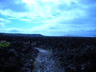
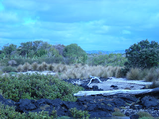
After looking at the baches, which were near the arrival point, we decided to take the long path along the western coast. Black, porous rock was everywhere. The path was made of it, lined with it, and there were chunks of it in piles in every direction. I'm amazed how such harsh, raw base material can come to foster such rich plantlife.
 |
| The path from Flax Point. A volcanic wasteland...except not really. |
 |
| A view of the coast from Flax Point. Unexpected diversity in one frame. |
We passed patch of rocks stretching far out into the water, home to a Black Back Gull colony. It's even on the map. I guess, being from Minnesota, I don't think of a group of birds being geographically constant enough to put down on paper. Though there are parking lots where you can always count on seagulls.
 |
| The gull colony, sort of visible as white specks dotting the rocks. |
 |
| Ian's jauntily dressed legs, making haste away from his despised seagulls. |
 |
| The Variable Oystercatcher, or Tōrea-Pango. |
Oystercatchers were another common sight, rooting around the shallows with their pointy bills. (A tourist at Mission Bay the day before had said, "They look like they have carrots stuck one their faces.") The one in the picture was a mother, who called to her children when we passed. You can see one of the offspring to the right of her, though the plumage blends in with the path.
Soon after this, we came across a sudden patch of gigantic trees. In seconds, the landscape went from flat and scruffy to grand and high.
 |
| I feel like, at the end of this wooded path, should lie our collective destiny or something. But actually it was just more gravel path. Symbolic? |
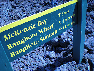
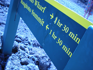
After exploring the west coast, we decided to go to the summit. Our map had estimated it would take 90 minutes to get this far, and it had taken us less than an hour. We decided not to trust the trail time estimates. Especially when...
 |
| ...we saw this sign. Note the time to the summit. |
 |
| This is the back of the same sign! LIES. Also note how the wharf time has been scratched out and repainted. |
The hike to the summit took us less than an hour, even with a long rest to take pictures. The elevation snuck up on us, and suddenly we realized we could see Auckland and all the surrounding islands from above.
 |
| In the foreground, wooded Rangitoto. In the distance, the sister island, Motutapu. |
 |
| Another view from the summit. |
In the top photo there, you can see Motutapu ("sacred island") which almost touches Rangitoto. Whereas Rangitoto is fairly covered in vegetation, Mototapu seems to be composed of bald hills. Their like opposites, complements. I wonder how they can be so nearby and with such different characteristics.
 |
| Ian in some...military fortification? |
And a final creepy note about the island. There are remains of prison barracks (which we didn't see) and also military buildings. The one in the picture, along the crater rim, is a simple cement building with no windows. New Zealand prepared for invasion during the World Wars, but was too out of the way I guess, and so the war never came this far south. So, unusually, these are ruins notable not for their history but their lack of history. Buildings mostly unused fallen into disuse.
I swear, the entire island is someday going to reclaim anything that humans have altered on it. I mean, abandoned barracks, dilapidated shacks, volcanic debris, misleading signs, and a group of college students on an island called
sky blood? Definitely the makings of a horror movie. I'd watch it.


No comments:
Post a Comment